Research conducted in HNP serves two main goals:
- To come up with feasible recommendations for management of the Park to deal with observed phenomena in an appropriate way. An example is the identified need to understand better the small rodent problem in the buffer zone, in order to know this factor of stress could also change the environmental conditions in HNP, and if so, how to react.
- It deals with the role HNP should play as an education- and research centre of national importance.
It will necessarily include research on management questions like:
- A takhi research program. The reintroduction process of takhi is far from finished. Many questions remain open, especially in relation to the adaptation of a growing population to the conditions in HNP.
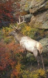
- Little is known of a number of aspects of ecosystem functioning that are very relevant for management. It includes: Migration of Gazelles and Marals and the biology of these two species.
- Wolf ecology.
 Predator-prey relations between wolves and large herbivores.
- The functioning and importance of forests for the ecosystems of HNP in general, through such processes as the hydrological balance of the Park, but also as habitat for all wildlife and bird species.
- The hydrological balance of the Park: study into geo-hydrological and hydrological processes.
- Grassland degradation in the Park and especially in the buffer zone. This includes research on small rodents as a factor of stress in the agricultural belt, and erosion assessment in the Park. Assessment of the importance of the Tuul river valley for waterfowl is important as well.
- Another research theme likely to become more important in the nearby future is related to wise use of natural resources inside HNP and buffer zone. It includes questions like: what numbers of tourists can be allowed to enter the Park without irreversible damage to the assets of the Park and what level of off-take is possible for products like medicinal plants, and how to organize this.
A management plan for the Park has been developed to make sure the objectives are reached and sustained.
The research staff of HNP is advised by a Scientific Board of Mongolian experts. The research proposals and the later results are discussed twice a year in workshops with the Scientific Board.
Monitoring
Monitoring for management is first and foremost an early-warning system, giving signals that something has changed (or not) and further investigation, eventually followed up by actions, may be warranted.
The annual monitoring programme at HNP deals with:
Takhi monitoring: data on the development of the population (numbers, birth, deaths, group composition and changes, dispersal data of juveniles, death causes, etc,), seasonal condition scoring, habitat use (size, distribution, food ecology, vegetation interaction), social behaviour studies of free roaming harems and bachelors (interactions and distances between the groups, etc.)
Monitoring of other wild mammals: line transects are two-weekly in which number, sex and possibly age class of the major large ungulates are observed. This is especially of importance for the Maral and Mongolian Gazelle to determine population trends. For other ungulates like Roe Deer, Argali sheep or Wild Boar, animal numbers are likely to be too small to give reliable data for comparison over the years. A second approach taken for these species is to depend on systematic observations from HNP professional staff and reliable outsiders (e.g. herdsmen).
Monitoring marmot numbers and distribution. Marmots are numerous in parts of the Park. Their impact on the vegetation is considerable. Therefore monthly animal and burrow counts along strategically chosen transects are executed.
Monitoring wolves. Wolves are the only large predators of the Park that occur in significant numbers. The wolf is an important part of the steppe ecosystem and a vulnerable species that is listed on the Red List of the IUCN. To find out how many wolves inhabited the Park and what their effect on the population of ungulates is, the staff records numbers and counts wolf dens (spring), counts wolves during the mating season (winter), wolf scats are analysed and local herdsmen are interviewed. The Przewalski horse, as well as other wild ungulates, are possible preys for wolves. The Park faces a dilemma: Must the wolves be regulated by hunting, to protect the takhi in this vulnerable stage? To find an answer to this dilemma, more research must be done. So far the wolves seem to be a serious threat for the takhi foals and weak animals. They are an important regulating factor, which, hopefully, will result in a strong and healthy Przewalski horse population.
Monitoring livestock. Land use around the Park is almost exclusively livestock husbandry with mainly sheep, goats, cattle and horses which causes two major problems:
- The competition for forage between wild herbivores and domestic livestock and
- The absolute need to keep the Takhi from mixing and interbreeding with domestic horses
Two-weekly road counts (by car) of livestock in the three main valleys of the Park, up to the Tuul valley are executed. Summer and winter camps are the focal points of livestock husbandry. The installation of new camps in the buffer zone are recorded. Ger interviews follow.
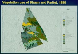
Monitoring of vegetation. When the Project was started there were insufficient maps. So, first, the maps had to be updated and completed. These maps show ecological factors as geology, hydrology and soil types. The next step was to make a vegetation map, which has been refined many times. The major vegetation types of HNP are the extensive perennial grasslands and the two patches of forest. In total eleven different vegetation types are distinguished: four steppe and two meadow communities, one tussock grassland, two shrub communities, one scrub and one woodland community.
Research on the quantity of the vegetation (Spectrometry, Remote sensing, out every 5 years) is done to gain insight in the productivity and seasonal dynamics of the main vegetation types and to estimate the grazing impact and food availability for herbivores. Permanent protected and open plots are made used for measurement height, together with clipping trials to relate to standing crop. Forest cover is measured every five years by Remote Sensing.
The floristic composition of vascular plants is monitored in permanent open plots to follow the species using the Braun-Blanquet method. Forage quality is assessed to understand the feeding value of different forage species throughout the year. This gives additional information to the results of forage availability.
Monitoring of grassland condition. Given the high pressure on the grassland vegetation – the main feeding ground of all herbivores-, as well as clear signs of changes in the negative sense in the buffer zone, signs of degradation have to be closely watched. Increases of Artemisia species and bare soil are indicators of deteriorating conditions. In order to follow trends in condition, annual monitoring of cover of indicator species in HNP and in the buffer zone are executed.
The Park has its own meteorological station to monitor temperatures, humidity and wind strength.
Carrying capacity
The maximum number of steppe-animals that can use the area without having a negative influence on the vegetation/soil complex must be determined (Carrying Capacity). Therefor all large herbivores, like the Takhi and the Red Deer, as well as small herbivores, like the Bobak marmots, the size of their homeranges and the vegetation in HNP need to be followed carefully in order to know the impact of all factors on each other.
Geographical Information System
All the information gained from the monitoring done in HNP is collected and combined in the Geographical Information System. This is a system of maps and data of the area with information from soil types to vegetation dynamics and from weather conditions to population dynamics. All these maps put together form a multi-dimensional overview of the area. This is of great value for a good management of the Park.
The GIS system is developed and maintained in cooperation with the Central Computer and Information Centre of the Mongolian Ministry for Nature, Environment and Tourism.